2025 TNGA PLANNING AIDS
TNGA PLANNING AIDS
Prepare for the Trans North Georgia (TNGA)
The 2025 TNGA Planning Aids are your essential companion for navigating one of the toughest bikepacking races in the U.S. Designed specifically for the Trans North Georgia (TNGA) route, these planning aids ensure you’re fully prepared for the ride ahead, offering everything you need for efficient planning and on-route support.
Choose the Small Bundle to get our two most popular planning aids, the Data Sheet and Town List. The Big Bundle includes all four of our planning aids: the Data Sheet, Town List, Mileage Chart, and Elevation Gain Chart.
Whether you're meticulously preparing before the race or referencing details during your ride, these comprehensive resources give you the tools you need for a smooth, successful TNGA adventure.
Highlights include:
- Southbound (SOBO) format to match the TNGA race direction.
- Available in US Standard units, ensuring accuracy in the measurements you need.
- Accurate Route Details: Includes mileage, elevation profiles, and key POIs specific to the TNGA route.
- Actionable Insights: Features cumulative distances, elevation gains, water sources, bike shops, resupply options, and critical notes to keep you on track throughout the race.
- Delivered as PDF files, non-editable for consistency across devices.
- $1.00 from every sale supports the bikepacking community via BikepackingRoots.com.
With these Planning Aids, you'll be able to focus on the adventure, not the logistics—before, during, and after your TNGA ride. The TNGA Planning Aids ensure you're prepared to tackle the challenges of this legendary route with confidence.
Key Features
Key Features
The 2025 TNGA Planning Aids provide riders with an unmatched level of detail, covering every aspect of the route to simplify planning and ensure success. Key features include:
- Detailed Point-of-Interest (POI) Data:
- Route-Specific Metrics:
- Practical Planning Tools:
- Versatile and Reliable:
Differences between Planning Aids
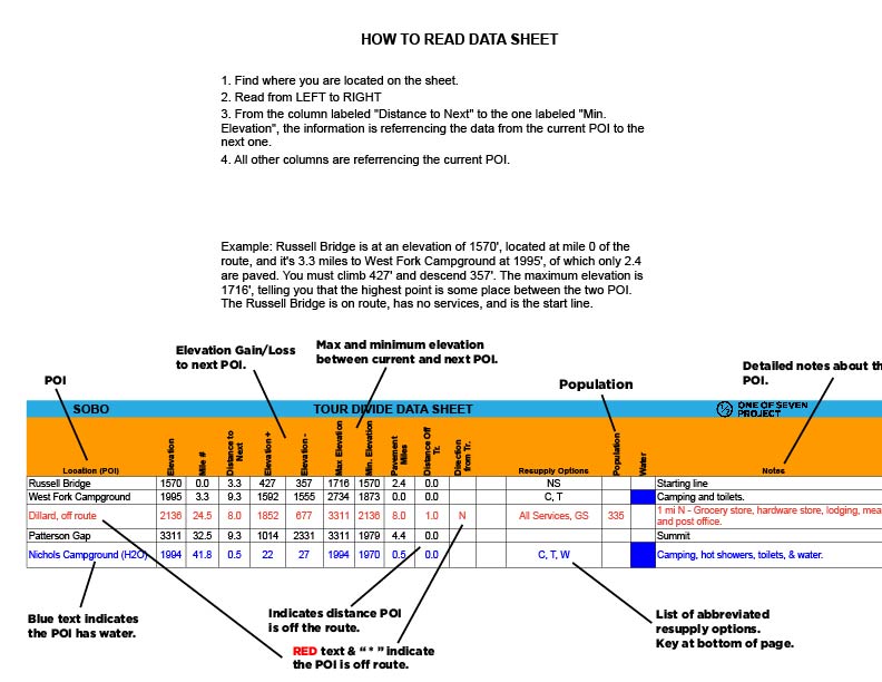
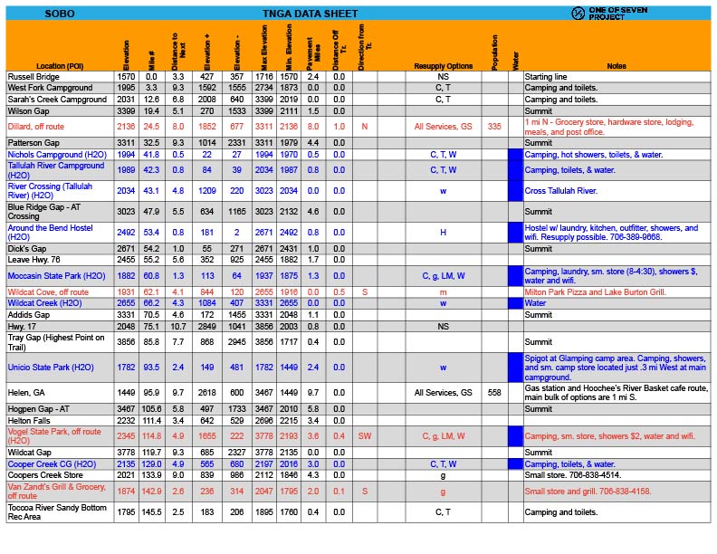
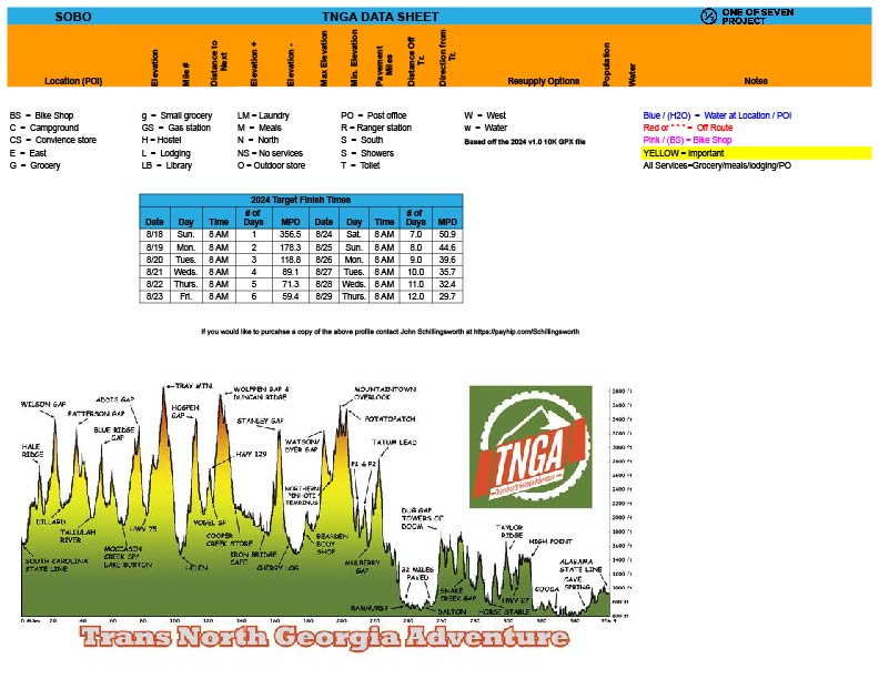
Data Sheet: The ultimate resource for granular details between POIs. Includes distance, elevation gain/loss, max/min elevations, pavement sections, bike shops, resupply points, water sources, and critical notes. Ideal for precise planning and on-route reference. Example: Covers A to B, then B to C, and so on.
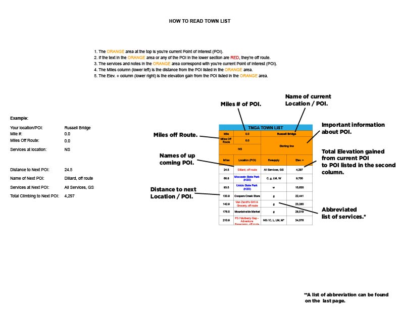
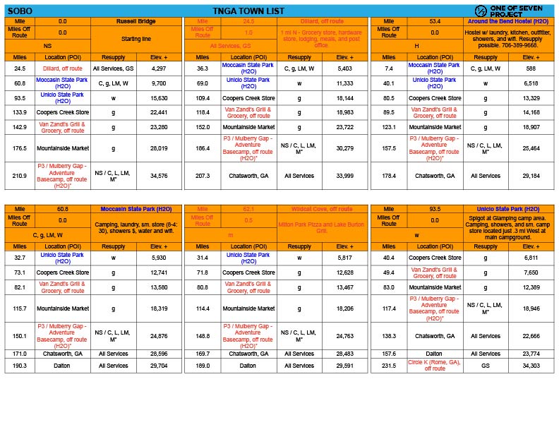
Town List: Provides cumulative distances, elevation gains/losses, and resupply points for each POI, saving you time and effort. Helps you avoid complex calculations to determine distances, elevation gains, and losses between multiple POI. Example: Covers A to B, A to C, A to D; the next section would include B to C, B to D, B to E, and so on. Available in Small and Big Bundles only.
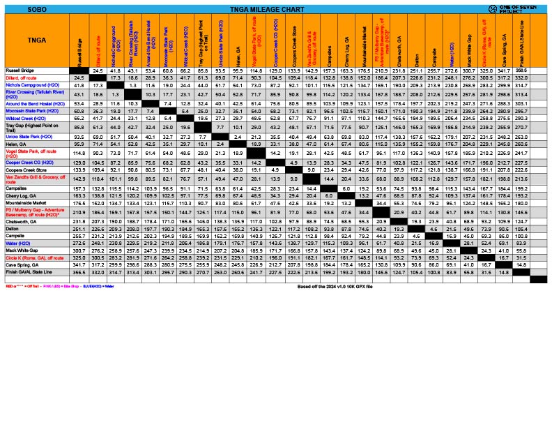
Mileage Chart: Quickly locate the total mileage between any two POIs on the route. A convenient way to plan long days or calculate progress. Sold exclusively in the Big Bundle.
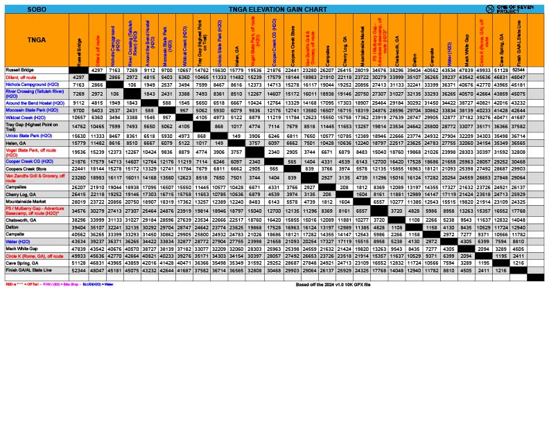
Elevation Gain Chart: Visualize total elevation gain between POIs to prepare for climbs and descents. A must-have for pacing your ride. Sold exclusively in the Big Bundle.